
San Juan River falling at Bluff, Utah; FEMA emergency declaration for New Mexico flooding, Oct. 27
Never walk, swim or drive through floodwater. Ready.gov says just six inches of moving water can knock you down, and one foot of moving water can sweep your vehicle away.
Past event. Flood · Arizona, Utah, Colorado, New Mexico · Oct. 21, 2026 to Oct. 29, 2026. In danger, call 911.
What is happening
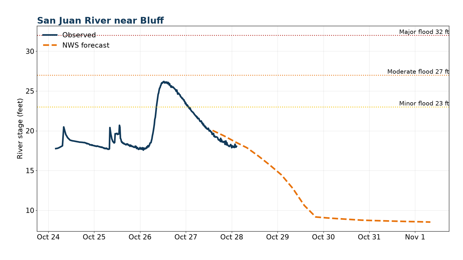
Latest (Tuesday morning, Oct. 27): NWS Grand Junction canceled its Flood Warning for the San Juan River in western Montezuma County, Colo., and southern San Juan County, Utah, at 6:01 AM MDT Tuesday. The San Juan near Bluff crested at 26.2 feet Monday and had fallen to about 20.9 feet by 6:30 AM MDT Tuesday per the NWS National Water Prediction Service gauge, below the 22-foot bankfull stage. NWS Salt Lake City's Flood Warning, updated 3:55 AM MDT, says moderate flooding continues along the San Juan River from downstream of Bluff to the Lake Powell terminus, including eastern Kane County, until noon MDT Tuesday; low-water crossings may not be passable and the river is running fast and high. In New Mexico, FEMA declared an emergency (EM-3660) on Oct. 26 for severe storms and flooding that began Oct. 22, covering Cibola, Rio Arriba, San Juan and Sandoval counties, the Jicarilla Apache Indian Reservation and the Pueblo of Acoma, Laguna, San Ildefonso and Zia pueblos; it provides Public Assistance for governments, not Individual Assistance. NWS Albuquerque says the Rio Puerco near Bernardo (Socorro County) was at 24.1 feet at 6 PM MDT Monday (flood stage 19.5 feet), the level at which the old Highway 60 bridge is overtopped and streets in the village of San Francisco flood; it is forecast to fall into minor flood early Tuesday, rise again to 21.8 feet Wednesday morning and fall below flood stage Thursday, with the warning in effect until late Thursday night. NWS Albuquerque also has a minor Flood Warning for the Rio Chama below Chamita until Tuesday afternoon. In Colorado, NWS Pueblo has Flood Warnings for the Rio Grande at Alamosa until Tuesday evening, for parts of Alamosa, Conejos, Costilla and Rio Grande counties until 11:45 AM MDT Tuesday, and for minor flooding on the Purgatoire River near Las Animas until late Wednesday night. Stay away from the river, never drive through flooded roads, and follow instructions from local officials. Earlier (late Monday, Oct. 26): NWS Grand Junction's Flood Warning, updated 11:07 PM MDT Monday, says the crest has passed at Bluff and will work toward Mexican Hat through sunrise Tuesday; NWS still calls catastrophic flooding along the San Juan River between Four Corners and Mexican Hat an emergency situation. The San Juan near Bluff peaked at 26.2 feet in the 24 hours ending 10:30 PM MDT Monday and was at 23.9 feet at 10:30 PM (flood stage 23 feet), below the 31.0 feet NWS had forecast Monday morning; NWS expects it to keep falling and drop below flood stage early Tuesday morning. Places that will flood include Mexican Hat, Tselakai Dezza, Bluff, Halchita, Montezuma Creek and Aneth, and the warning runs until 8 AM MDT Tuesday. NWS Salt Lake City says flooding continues downstream from Bluff to Lake Powell through at least Tuesday morning, including eastern Kane County. Repeated rounds of heavy rain over Arizona, southern Utah, Colorado and northern New Mexico have caused life-threatening flash flooding since Thursday, Oct. 22. The San Juan River at Pagosa Springs, Colo., crested at 14.67 feet around 12:30 AM MDT Friday per the NWS National Water Prediction Service gauge, in major flood (flood stage 10.5 feet) and above the 13.5-foot crest of June 29, 1927 in the NWS flood history, and was falling (13.1 feet at 3 AM MDT); NWS Grand Junction said that at 14.5 feet water reaches the foundations of some homes in the San Juan River Ranch northeast of town. NWS Grand Junction said several structures were flooded and numerous roads were closed across Archuleta County, law enforcement reported road washouts in southeastern La Plata County near Bayfield and Ignacio, and flooding continued early Friday around Durango and the Animas River. NWS Pueblo said Highway 160 over Wolf Creek Pass was closed, several structures were flooded, the Park Creek bridge was washed away, and evacuations were underway from Wolf Creek Ranch to Fun Valley in Rio Grande County. As of Friday morning, NWS Pueblo forecast the Rio Grande near Del Norte to crest in moderate flood at about 6.6 feet Friday afternoon, just below the 6.8-foot record, threatening homes and an RV park near Del Norte Park, and emergency management reported flooding along the Conejos River around Antonito, Manassa and Sanford. Downstream in New Mexico, NWS Albuquerque said the current extent of San Juan River flooding has not been observed since before Navajo Dam was completed in 1962. The San Juan River at Farmington reached 14.07 feet at 11 AM MDT Friday per the NWS National Water Prediction Service gauge, in major flood (flood stage 8.5 feet), and NWS Albuquerque called it the flood of record, above the 12.3-foot crest of Sept. 6, 1909; late Friday night NWS said the river had likely crested and would fall below flood stage Saturday afternoon. NWS said the Animas River at Farmington was likely near a crest of about 12 feet late Friday night, flooding the riverwalk, with water levels not this high since the flood of 1927; the Animas near Cedar Hill reached 11.9 feet Friday evening, above the 11.5-foot crest of June 1949 in the NWS flood history, where areas that have never flooded before were likely to be inundated; and the La Plata River below Redmesa was forecast to crest near 10.5 feet, close to its 10.8-foot record of 1934. The San Juan River at Shiprock was at 17.3 feet at 10 PM MDT Friday and is forecast to crest near 20.7 feet late Saturday morning, in major flood. In southeastern Utah, NWS Grand Junction said the San Juan River was cresting around midnight Friday between Bluff and Mexican Hat, with a second, higher crest forecast at Mexican Hat Sunday into Monday; its Flood Warning for Bluff, Mexican Hat, Montezuma Creek, Aneth and western Montezuma County runs until 9 AM MDT Monday. The Rio Chama above Abiquiu was in moderate flood Friday morning. Earlier, NWS Flagstaff reported a nearly 6-foot rise in Oak Creek at Sedona and NWS Salt Lake City warned of life-threatening flash flooding in Zion National Park and Springdale. Follow evacuation orders from local officials, check the live panel and your local NWS office.
Areas under warnings include north-central and eastern Arizona, including Sedona and Oak Creek Canyon, the Verde Valley, Fossil Creek, Lees Ferry and the Paria River; southern Utah, including Zion National Park, Springdale and San Juan County (Bluff, Mexican Hat, Montezuma Creek and Aneth); southwest and south-central Colorado, including the San Juan River at Pagosa Springs, Durango and the Animas River, Bayfield, Ignacio, Mancos, Telluride, Wolf Creek Pass, South Fork, Del Norte, the Upper Rio Grande Valley and the Conejos River around Antonito and Manassa; and northern New Mexico, including Farmington, Shiprock, Cedar Hill, the Rio Chama near Abiquiu, Gallup, Grants, Interstate 40 and San Juan County, with Flood Watches across much of the region.
Source: NWS Grand Junction, Salt Lake City, Pueblo, Flagstaff and Albuquerque Flash Flood and Flood Warnings, Oct. 22-27, 2026 (Grand Junction San Juan River warning canceled 6:01 AM MDT Oct. 27); FEMA EM-3660; NWS National Water Prediction Service gauges (San Juan River at Pagosa Springs, Farmington and Bluff). Warnings change; the live panel below is the current word from NWS.
Let family know you’re OK
Makes a message and picture you can text. Nothing is saved on our servers.
Make a check-in message
Local help near you
Open shelters and FEMA Disaster Recovery Centers in Arizona, Utah, Colorado, New Mexico, straight from FEMA.
Loading open shelters…
Follow for storm updates: Facebook (opens in a new tab)X (opens in a new tab)
Live NWS alerts for the affected areas
Loading live data…
FEMA disaster declarations
Loading live data…
Confirmed damage
Only official reports: NWS Local Storm Reports and damage surveys, plus statements from FEMA, USGS and state or county emergency management. No news or social media rumors.
Show storm reports and official statements
Loading NWS storm reports…
Official statements and assessments
- FEMA declaration 2026-10-26T00:00:00-06:00
FEMA emergency declaration EM-3660, New Mexico Severe Storms and Flooding, declared Oct. 26, 2026 (incident period Oct. 22 and continuing). Designated: Cibola, Rio Arriba, San Juan and Sandoval counties, the Jicarilla Apache Indian Reservation, and the Pueblo of Acoma, Laguna, San Ildefonso and Zia pueblos. Public Assistance only; Individual Assistance not declared.
Source: FEMA, checked 2026-10-27T09:45:00-04:00 - River crest 2026-10-23T13:00:00-04:00
San Juan River at Farmington, NM was at 14.07 ft at 11 AM MDT Oct. 23 (observed), in major flood (flood stage 8.5 ft) and above the 12.3 ft crest of Sept. 6, 1909 in the NWS flood history.
Source: NWS National Water Prediction Service, checked 2026-10-23T15:35:00-04:00 - River crest 2026-10-23T02:30:00-04:00
San Juan River at Pagosa Springs, CO crested at 14.67 ft around 12:30 AM MDT Oct. 23 (observed), in major flood (flood stage 10.5 ft) and above the 13.5 ft crest of June 29, 1927 in the NWS flood history; NWS says water reaches some home foundations in the San Juan River Ranch at 14.5 ft. The river was falling, at 13.1 ft by 3 AM MDT.
Source: NWS National Water Prediction Service, checked 2026-10-23T06:35:00-04:00
Preliminary reports; official totals may change.
Official state and local links
- Arizona Department of Emergency and Military AffairsState emergency management
- Utah Division of Emergency ManagementState emergency management
- Colorado Division of Homeland Security and Emergency ManagementState emergency management
- New Mexico Department of Homeland Security and Emergency ManagementState emergency management
- FEMA: New Mexico Severe Storms and Flooding (EM-3660)Emergency declaration, Oct. 26, 2026
- Archuleta County Emergency ServicesArchuleta County, CO (Pagosa Springs)
- San Juan River at Pagosa Springs (NWS gauge)Current river level and NWS forecast
- San Juan River at Farmington (NWS gauge)Current river level and NWS forecast
- San Juan River near Bluff (NWS gauge)Current river level and NWS forecast
- AZ511Arizona road conditions and closures
- UDOT TrafficUtah road conditions and closures
- COtripColorado road conditions and closures
- NMRoadsNew Mexico road conditions and closures
- NWS FlagstaffForecasts and warnings · NWS
- NWS Salt Lake CityForecasts and warnings · NWS
- NWS Grand JunctionForecasts and warnings · NWS
- NWS AlbuquerqueForecasts and warnings · NWS
- NWS PuebloForecasts and warnings · NWS
- NWS PhoenixForecasts and warnings · NWS
- NWS TucsonForecasts and warnings · NWS
During: stay safe
- Get to safe shelter right away and evacuate if officials tell you to.
- Turn Around, Don't Drown: do not walk, swim or drive through floodwater, and never drive around barricades.
- Stay off bridges over fast-moving water.
- If you're trapped in a building, go to the highest level. Do not climb into a closed attic; only go on the roof if necessary, then signal for help.
- If your car is trapped in rapidly moving water, stay inside. Get on the roof if water rises inside the car.
Source: (Ready.gov: Floods)
After: recover
- Return home only when officials say it's safe.
- Stay out of floodwater: it can be contaminated, hide debris, or be electrically charged by downed lines.
- Don't touch electrical equipment if it's wet or you're standing in water.
- Wear gloves, boots and protective clothing to clean up, and dry your home within 24 to 48 hours to limit mold.
- Homeowners insurance usually doesn't cover flooding; if you have NFIP or private flood insurance, file your claim and photograph everything first.
More official guidance
- NWS flood safetyFlood and flash flood safety · NWS
- National Water Prediction ServiceRiver forecasts and flood levels · NOAA
- Ready.gov: FloodsBefore, during and after · Ready.gov
- Water damage and mold guideDrying out and cleanup
- Flood insurance waiting periodNFIP 30-day wait explained
- Nor'easter and coastal flood guideCoastal flood alerts and what to do
- King tides and sunny-day floodingHigh tide flooding explained
- Flooding: full safety guide
Get help
- Roads & closures511, road conditions, flooding
- Find shelterOpen shelters and hotel help
- Boil-water noticesIs your tap water safe?
- FEMA & money helpAid, loans and free legal help
- Tarps & roof helpTarps, roof help and volunteer crews
- Safety firstGas, power lines, CO, floodwater
- After the storm: housing, mental health, money
- Insurance photo checklist
Common questions
Where can I see current warnings for the arizona and four corners flash flooding?
The live panel on this page pulls active alerts straight from the National Weather Service for the affected zones in Arizona, Utah, Colorado, New Mexico. You can also check your local NWS office or weather.gov.
Is FEMA assistance available for the arizona and four corners flash flooding?
Only if a federal disaster is declared for your county. The FEMA panel on this page shows any declarations as they come in; you can also check DisasterAssistance.gov or call 1-800-621-3362.
How much water does it take to sweep away a car?
Ready.gov says one foot of moving water can sweep your vehicle away, and just six inches of moving water can knock you down.
Does homeowners insurance cover flood damage?
Usually not. Ready.gov notes homeowners policies do not cover flooding; flood coverage comes from the National Flood Insurance Program or a private flood policy, which typically takes 30 days to start.