
Las Vegas flash flood warning Halloween night; major San Juan River flooding forecast at Pagosa Springs
Never walk, swim or drive through floodwater. Ready.gov says just six inches of moving water can knock you down, and one foot of moving water can sweep your vehicle away.
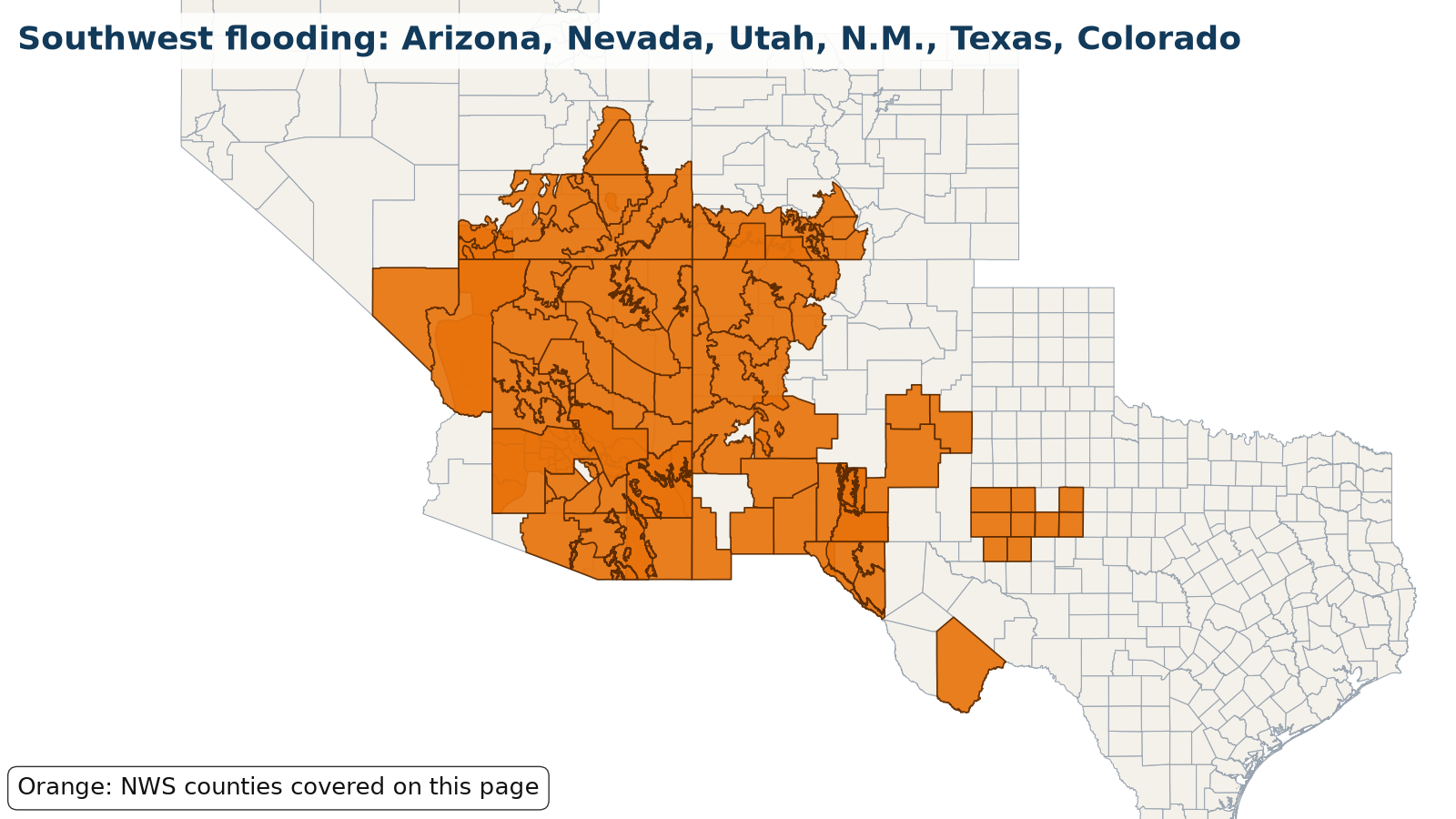
Active. Flood · Nevada, New Mexico, Texas, Arizona, Utah, Colorado · Oct. 29, 2026 to Nov. 4, 2026. In danger, call 911.
What is happening
On Halloween evening, Oct. 31, NWS Las Vegas issued a Flash Flood Warning at 6:21 PM PDT until 9:15 PM PDT for central Clark County, Nevada, including Las Vegas, North Las Vegas, Lone Mountain, Centennial Hills, Aliante, Summerlin, North Las Vegas Airport and Floyd Lamb Park, after radar showed 0.25 to 0.75 inches of rain from thunderstorms, with a considerable, life-threatening flash flood threat to streets, underpasses and washes. On Saturday morning, Oct. 31, NWS Grand Junction issued a Flood Warning for the San Juan River at Pagosa Springs in Archuleta County, Colorado, where major flooding is forecast from Sunday afternoon to Monday evening: the river, at 7.0 feet at 9 AM MDT Saturday, is expected to rise above its 10.5-foot flood stage Sunday afternoon and crest near 17.0 feet early Monday, Nov. 2, approaching the flood of record. NWS Grand Junction also issued a Flood Warning for minor flooding on the La Plata River at Hesperus in La Plata County, Colorado, with a crest near 5.8 feet late Sunday evening, also approaching the flood of record. At 2:41 PM MST Saturday, Oct. 31, NWS Phoenix issued a Flood Warning until 8 AM MST Monday, Nov. 2, for Rio Verde and Fort McDowell in Maricopa County, Arizona, where flooding is already occurring as streams keep rising from releases upstream from Bartlett Dam. At 3:52 PM MST Saturday, NWS Phoenix issued a new Flood Warning for the Salt River in Maricopa County until 7:45 AM MST Monday, Nov. 2, saying flooding is occurring along the river from an upstream floodgate release and low-water crossings are inundated and may not be passable, including near Granite Reef Dam and Tempe Marketplace. Earlier Saturday, SRP was releasing 1,650 cubic feet per second below Granite Reef Dam, flooding low-water crossings upstream of Tempe Town Lake such as McKellips Road. An earlier Saturday Flood Warning for Tonto Creek near Tonto Basin in Gila County has ended. An earlier Flood Warning for Indian Bend Wash in Scottsdale has expired. Friday evening, Oct. 30, NWS Phoenix Flash Flood Warnings for Maricopa County, Arizona, said local law enforcement reported multiple water rescues after 0.75 to 2.25 inches of rain: at 7:48 PM MST in Scottsdale, Paradise Valley and Scottsdale Airport, including Loop 101 between mile markers 36 and 43 (until 10:15 PM MST), and at 9:10 PM MST in Phoenix, Paradise Valley, Piestewa Peak Park, Camelback Mountain and the Arizona State Fairgrounds (until 10:45 PM MST), with a considerable, life-threatening flash flood threat. Warnings were also extended until 10 PM MST for Scottsdale, Cave Creek, Carefree, Desert Mountain and Scottsdale Airport and for New River, Cave Creek and Anthem, where several streamflow gauges remained above alarm stage. NWS said flooding impacts will continue though no additional rainfall is expected, and urged extra caution at night. Earlier Friday afternoon, NWS Las Vegas issued Flash Flood Warnings for a considerable, life-threatening flash flood threat in Henderson, Lake Las Vegas and Railroad Pass (up to 1.75 inches of rain, flash flooding already occurring), in Las Vegas, North Las Vegas, Paradise and Nellis AFB (up to 1 inch), and until 5:45 PM PDT in Bullhead City, Laughlin, Oatman and Mohave Valley. It also issued a Severe Thunderstorm Warning for quarter-size hail near Bullhead City and Laughlin and Flood Advisories from Boulder City to Lake Mead. In southwest Utah, NWS Salt Lake City had a Flood Warning through Friday evening for the upper Santa Clara River from Pine Valley to just below Baker Reservoir, where USGS gauges and cameras showed rapid rises. More rounds of heavy rain are forecast this weekend. Flood Watches run until 5 AM MST Monday, Nov. 2, for the Phoenix, Tucson and Flagstaff areas and, from Saturday evening through late Sunday night, for northwest Arizona (NWS Las Vegas), where over an inch of rain is possible on saturated soils. Watches also cover southern Utah including Zion National Park and southwest Colorado through Monday. NWS Albuquerque kept a Flood Watch for northwest, north central and west central New Mexico from late Saturday night through Monday morning, with 1 to 2 inches of rain expected Sunday into Monday near and west of the Continental Divide and near 3 inches in the Tusas Mountains near Chama, falling on very saturated soils. On Saturday it also issued river Flood Watches for the Animas River near Cedar Hill and at Farmington and the La Plata River below Redmesa in San Juan County, where flood stage may be reached Monday, and NWS Pueblo has a Flood Watch for the western San Luis Valley (Del Norte, Antonito, Mogote) from Sunday afternoon through late Tuesday night, Nov. 3, as rain and melting snow send high flows down the Rio Grande and Conejos River. In Texas, NWS Midland/Odessa had a Flood Warning for the Rio Grande at Rio Grande Village in Big Bend National Park, which is no longer in effect; Friday morning Flash Flood Warnings for Midland, Odessa, Lamesa, Big Spring and Snyder have expired, after spotters reported several roads underwater in Stanton. In New Mexico, NWS Albuquerque issued Flood Warnings for Socorro County, since expired, after emergency management reported a levee breach near Bernardo Thursday. The National Hurricane Center said moisture from Vance, combined with other Pacific moisture, fueled the heavy rain. Never drive through flooded roads or washes.
Areas under warnings include Southwest Colorado (San Juan River at Pagosa Springs, Archuleta County, and La Plata River at Hesperus, La Plata County); Phoenix metro, Arizona (Verde River area at Rio Verde and Fort McDowell, Salt River below Granite Reef Dam including McKellips Road and Tempe Marketplace, Scottsdale, Paradise Valley, Cave Creek, Carefree, Desert Mountain, New River and Anthem, Maricopa County); Tonto Creek near Tonto Basin, Gila County, Arizona; Southern Nevada and northwest Arizona (Las Vegas, North Las Vegas, Summerlin, Centennial Hills, Aliante, Henderson, Lake Las Vegas, Laughlin, Bullhead City and Mohave Valley); Southwest Utah (Santa Clara River in Pine Valley, Washington County); flood watches across Arizona (Phoenix, Tucson, Flagstaff, Grand Canyon and northwest Arizona areas), southern and eastern Utah including Zion National Park, southwest Colorado and the San Luis Valley, and northwest New Mexico, including river flood watches for the Animas River (Cedar Hill and Farmington) and La Plata River below Redmesa; West Texas, including Brewster County (Rio Grande in Big Bend National Park) and earlier warnings for Midland, Odessa, Lamesa, Big Spring and El Paso; and southern and central New Mexico, including Socorro County.
Source: NWS Las Vegas Flash Flood Warning (central Clark County, Nev.), issued Oct. 31, 2026, 6:21 PM PDT. Warnings change; the live panel below is the current word from NWS.
Let family know you’re OK
Makes a message and picture you can text. Nothing is saved on our servers.
Make a check-in message
Local help near you
Open shelters and FEMA Disaster Recovery Centers in Nevada, New Mexico, Texas, Arizona, Utah, Colorado, straight from FEMA.
Loading open shelters…
Follow for storm updates: Facebook (opens in a new tab)X (opens in a new tab)
Live NWS alerts for the affected areas
Loading live data…
FEMA disaster declarations
Loading live data…
Confirmed damage
Only official reports: NWS Local Storm Reports and damage surveys, plus statements from FEMA, USGS and state or county emergency management. No news or social media rumors.
Show storm reports and official statements
Loading NWS storm reports…
Official statements and assessments
- Official statement 2026-10-29T18:46:00-06:00
NWS Albuquerque Flood Warning (6:46 PM MDT Oct. 29): emergency management reported flooding caused by a levee breach in the San Francisco area near Bernardo, Socorro County, NM, affecting La Joya, Bernardo, San Francisco and Contreras; a second warning says flooding was reported in the Escondida and Pueblito communities and several roads were impassable near San Pedro.
Source: NWS Albuquerque, checked 2026-10-29T21:40:00-04:00
Preliminary reports; official totals may change.
Official state and local links
- New Mexico Department of Homeland Security and Emergency ManagementState emergency management
- Texas Division of Emergency ManagementState emergency management
- Arizona Department of Emergency and Military AffairsState emergency management
- City of SocorroSocorro, NM local information
- NMRoadsNew Mexico road conditions and closures
- DriveTexasTexas road conditions and closures
- AZ511Arizona road conditions and closures
- San Juan River at Pagosa Springs gauge (NWS)River level and forecast for Pagosa Springs, Archuleta County, Colo.
- NWS El Paso/Santa TeresaForecasts and warnings · NWS
- NWS AlbuquerqueForecasts and warnings · NWS
- NWS TucsonForecasts and warnings · NWS
- NWS PhoenixForecasts and warnings · NWS
- NWS Midland/OdessaForecasts and warnings · NWS
- NWS LubbockForecasts and warnings · NWS
- NWS Salt Lake CityForecasts and warnings · NWS
- NWS Las VegasForecasts and warnings · NWS
- NWS FlagstaffForecasts and warnings · NWS
- NWS Grand JunctionForecasts and warnings · NWS
- NWS PuebloForecasts and warnings · NWS
During: stay safe
- Get to safe shelter right away and evacuate if officials tell you to.
- Turn Around, Don't Drown: do not walk, swim or drive through floodwater, and never drive around barricades.
- Stay off bridges over fast-moving water.
- If you're trapped in a building, go to the highest level. Do not climb into a closed attic; only go on the roof if necessary, then signal for help.
- If your car is trapped in rapidly moving water, stay inside. Get on the roof if water rises inside the car.
Source: (Ready.gov: Floods)
After: recover
- Return home only when officials say it's safe.
- Stay out of floodwater: it can be contaminated, hide debris, or be electrically charged by downed lines.
- Don't touch electrical equipment if it's wet or you're standing in water.
- Wear gloves, boots and protective clothing to clean up, and dry your home within 24 to 48 hours to limit mold.
- Homeowners insurance usually doesn't cover flooding; if you have NFIP or private flood insurance, file your claim and photograph everything first.
More official guidance
- NWS flood safetyFlood and flash flood safety · NWS
- National Water Prediction ServiceRiver forecasts and flood levels · NOAA
- Ready.gov: FloodsBefore, during and after · Ready.gov
- Water damage and mold guideDrying out and cleanup
- Flood insurance waiting periodNFIP 30-day wait explained
- Nor'easter and coastal flood guideCoastal flood alerts and what to do
- King tides and sunny-day floodingHigh tide flooding explained
- Flooding: full safety guide
Get help
- Roads & closures511, road conditions, flooding
- Find shelterOpen shelters and hotel help
- Boil-water noticesIs your tap water safe?
- FEMA & money helpAid, loans and free legal help
- Tarps & roof helpTarps, roof help and volunteer crews
- Safety firstGas, power lines, CO, floodwater
- After the storm: housing, mental health, money
- Insurance photo checklist
Common questions
Where can I see current warnings for the southwest flooding: arizona, nevada, utah, n.m., texas, colorado?
The live panel on this page pulls active alerts straight from the National Weather Service for the affected zones in Nevada, New Mexico, Texas, Arizona, Utah, Colorado. You can also check your local NWS office or weather.gov.
Is FEMA assistance available for the southwest flooding: arizona, nevada, utah, n.m., texas, colorado?
Only if a federal disaster is declared for your county. The FEMA panel on this page shows any declarations as they come in; you can also check DisasterAssistance.gov or call 1-800-621-3362.
How much water does it take to sweep away a car?
Ready.gov says one foot of moving water can sweep your vehicle away, and just six inches of moving water can knock you down.
Does homeowners insurance cover flood damage?
Usually not. Ready.gov notes homeowners policies do not cover flooding; flood coverage comes from the National Flood Insurance Program or a private flood policy, which typically takes 30 days to start.