
Western Alaska: high surf at Hooper Bay, coastal flood advisory for the Kuskokwim Delta coast, Oct. 29–31
Never walk, swim or drive through floodwater. Ready.gov says just six inches of moving water can knock you down, and one foot of moving water can sweep your vehicle away.
Past event. Flood · Alaska · Oct. 22, 2026 to Oct. 31, 2026. In danger, call 911.
What is happening
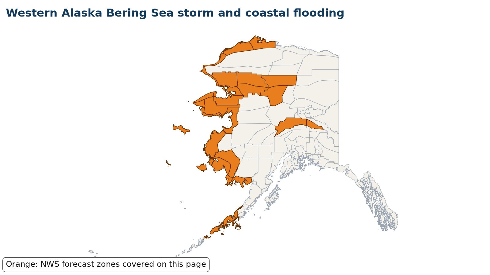
Latest (Thursday, Oct. 29): NWS Fairbanks now has a High Surf Advisory for the Yukon Delta coast, specifically Hooper Bay, until 1 AM AKDT Saturday, Oct. 31, with water levels 2.5 to 3.5 feet above the normal high tide expected during the Thursday and Friday high tides; beach property and the lowest buildings may be impacted, and multiple high tides above normal may cause localized beach erosion. The rest of the Yukon Delta coast could see about 1 to 3 feet above the normal high tide line. NWS Anchorage's Coastal Flood Advisory for the Kuskokwim Delta coast and Nunivak Island, including Kipnuk, Kwigillingok and Kongiganak, runs through 7 AM AKDT Saturday, with water 1.5 to 3 feet above the normal highest tide line and south to southeast gusts up to 35 to 50 mph. Earlier (Wednesday, Oct. 28): NWS Fairbanks replaced the Hooper Bay Coastal Flood Watch with a Coastal Flood Advisory from 7 AM Thursday, Oct. 29, to 1 AM AKDT Saturday, Oct. 31. Water levels 2 to 4 feet above the normal high tide are expected at Hooper Bay during the Thursday and Friday high tides, which may threaten beach property, the lowest buildings and the access road, with localized beach erosion; the rest of the Yukon Delta coast could see 1 to 3 feet above the normal high tide line. NWS Anchorage issued a Coastal Flood Advisory for the Kuskokwim Delta coast, including Kipnuk, Kwigillingok and Kongiganak, from 11 PM AKDT Thursday through 7 AM AKDT Saturday, with water 1.5 to 3 feet above the normal highest tide line (around 2 feet at Kwigillingok and 2.5 feet at Kipnuk) and south to southeast gusts up to 35 to 50 mph. The Winter Storm Warning for the south slopes of the western Brooks Range and the Noatak Valley runs until 4 PM AKDT Thursday. Earlier (Tuesday, Oct. 27): NWS Fairbanks issued a Coastal Flood Watch for Hooper Bay on the Yukon Delta coast from Thursday morning, Oct. 29, through late Friday night, Oct. 30. Water could reach 4 to 6 feet above the normal high tide line at Hooper Bay with the Thursday and Friday high tides, inundating low-lying areas including the airport access road, with shore erosion; the rest of the Yukon Delta coast could see 2 to 4 feet above the normal high tide line. The High Wind Warning for the Bering Strait coast, Shishmaref and St. Lawrence Island, with gusts up to 60 mph, runs until 4 PM AKDT Tuesday, and High Surf Advisories with breaking waves 2 to 4 feet above the normal high tide line (3 to 5 feet at Elim) continue along the Seward Peninsula, Norton Sound, Kivalina and Yukon Delta coasts until 4 AM AKDT Wednesday. A Winter Storm Warning calls for 6 to 18 inches of snow at Red Dog Mine and the south slopes of the western Brooks Range from 10 AM Tuesday to 4 PM AKDT Thursday. Earlier (Oct. 25-26): NWS Fairbanks canceled the Coastal Flood Watches for Shishmaref, the Baldwin Peninsula and northern Seward Peninsula, Kivalina and Red Dog Dock, and the Western Arctic coast on Sunday afternoon, Oct. 25,. A High Wind Warning for the Bering Strait coast, Diomede, Shishmaref and St. Lawrence Island calls for south winds of 30 to 40 mph with gusts up to 60 mph until 4 PM AKDT Tuesday, which may damage property and cause power outages, and High Surf Advisories continue along the Seward Peninsula, Norton Sound, Kivalina and the Yukon and Kuskokwim delta coasts. The Brooks Range Winter Storm Warnings have ended. Earlier: NWS Fairbanks's Coastal Flood Warning for the Yukon Delta coast runs from 4 AM Friday through 10 PM Sunday, with water 5 to 7 feet above the normal high tide line expected at Hooper Bay, where beach property and the lowest buildings will be inundated and access to the airstrip will likely be cut off; water peaks around midday Friday and stays high at each high tide into the weekend. On Thursday, Oct. 22, NWS changed the southern Seward Peninsula coast and Shishmaref and the Bering Strait coast from watches to Coastal Flood Advisories for minor flooding: about 6 feet above the normal high tide line at Nome and Golovin, where water may approach low-lying homes in Nome's Belmont Subdivision, and 4 to 6 feet along the Bering Strait coast, including Teller, Brevig Mission and Wales. NWS Anchorage has a Coastal Flood Advisory for the Kuskokwim Delta coast on Friday, most likely 2 to 3 feet above the normal high tide line at Kipnuk and Kwigillingok. Blizzard Warnings cover the Seward Peninsula and Bering Strait coast Friday into Saturday with gusts to 60 to 65 mph, and NWS Fairbanks added a Blizzard Warning for the Western Arctic coast from 1 PM Friday to 7 AM Saturday with gusts to 65 mph and a High Surf Advisory for Point Hope and Point Lay; High Wind Warnings call for gusts up to 75 mph that could cause power outages.
Areas under warnings include Hooper Bay and the rest of the Yukon Delta coast under a Coastal Flood Advisory from 7 AM Thursday to 1 AM AKDT Saturday; the Kuskokwim Delta coast, including Kipnuk, Kwigillingok and Kongiganak, under a Coastal Flood Advisory from 11 PM Thursday through 7 AM AKDT Saturday; and a Winter Storm Warning for the south slopes of the western Brooks Range and the Noatak Valley until 4 PM AKDT Thursday.
Source: NWS Fairbanks and NWS Anchorage Coastal Flood, High Surf, Blizzard, High Wind and Winter Storm alerts, Oct. 22-29, 2026. Warnings change; the live panel below is the current word from NWS.
Let family know you’re OK
Makes a message and picture you can text. Nothing is saved on our servers.
Make a check-in message
Local help near you
Open shelters and FEMA Disaster Recovery Centers in Alaska, straight from FEMA.
Loading open shelters…
Follow for storm updates: Facebook (opens in a new tab)X (opens in a new tab)
Live NWS alerts for the affected areas
Loading live data…
FEMA disaster declarations
Loading live data…
Confirmed damage
Only official reports: NWS Local Storm Reports and damage surveys, plus statements from FEMA, USGS and state or county emergency management. No news or social media rumors.
Show storm reports and official statements
Loading NWS storm reports…
Preliminary reports; official totals may change.
Official state and local links
- Alaska Division of Homeland Security and Emergency ManagementState emergency management
- Alaska 511Alaska road conditions and closures
- NWS FairbanksForecasts and warnings · NWS
- NWS AnchorageForecasts and warnings · NWS
During: stay safe
- Get to safe shelter right away and evacuate if officials tell you to.
- Turn Around, Don't Drown: do not walk, swim or drive through floodwater, and never drive around barricades.
- Stay off bridges over fast-moving water.
- If you're trapped in a building, go to the highest level. Do not climb into a closed attic; only go on the roof if necessary, then signal for help.
- If your car is trapped in rapidly moving water, stay inside. Get on the roof if water rises inside the car.
Source: (Ready.gov: Floods)
After: recover
- Return home only when officials say it's safe.
- Stay out of floodwater: it can be contaminated, hide debris, or be electrically charged by downed lines.
- Don't touch electrical equipment if it's wet or you're standing in water.
- Wear gloves, boots and protective clothing to clean up, and dry your home within 24 to 48 hours to limit mold.
- Homeowners insurance usually doesn't cover flooding; if you have NFIP or private flood insurance, file your claim and photograph everything first.
More official guidance
- NWS flood safetyFlood and flash flood safety · NWS
- National Water Prediction ServiceRiver forecasts and flood levels · NOAA
- Ready.gov: FloodsBefore, during and after · Ready.gov
- Water damage and mold guideDrying out and cleanup
- Flood insurance waiting periodNFIP 30-day wait explained
- Nor'easter and coastal flood guideCoastal flood alerts and what to do
- King tides and sunny-day floodingHigh tide flooding explained
- Flooding: full safety guide
Get help
- Roads & closures511, road conditions, flooding
- Find shelterOpen shelters and hotel help
- Boil-water noticesIs your tap water safe?
- FEMA & money helpAid, loans and free legal help
- Tarps & roof helpTarps, roof help and volunteer crews
- Safety firstGas, power lines, CO, floodwater
- After the storm: housing, mental health, money
- Insurance photo checklist
Common questions
Where can I see current warnings for the western alaska bering sea storm and coastal flooding?
The live panel on this page pulls active alerts straight from the National Weather Service for the affected zones in Alaska. You can also check your local NWS office or weather.gov.
Is FEMA assistance available for the western alaska bering sea storm and coastal flooding?
Only if a federal disaster is declared for your county. The FEMA panel on this page shows any declarations as they come in; you can also check DisasterAssistance.gov or call 1-800-621-3362.
How much water does it take to sweep away a car?
Ready.gov says one foot of moving water can sweep your vehicle away, and just six inches of moving water can knock you down.
Does homeowners insurance cover flood damage?
Usually not. Ready.gov notes homeowners policies do not cover flooding; flood coverage comes from the National Flood Insurance Program or a private flood policy, which typically takes 30 days to start.