
Winter Storm Warnings for Sierra, Lake Tahoe, Shasta and Siskiyou, Nov. 17–20: up to 4 feet of snow
Do this right now
- Stay off the roads if you can.
- Run generators outside only, at least 20 feet from windows and doors.
- Check the live warnings for this area before you travel.
- Check on older neighbors.
Other active storms: East Central Florida coastal flooding · Southwest flooding: Arizona, Nevada, Utah, N.M., Texas, Colorado · South Florida and Treasure Coast heavy rain flooding · Western Alaska Bering Sea storm, coastal flooding and blizzard · Florida east coast heavy rain and flood watches
Under a winter storm warning, stay off roads if you can, keep generators and grills outdoors at least 20 feet from windows and doors, and watch for frostbite and hypothermia.
Active. Winter storm · California, Nevada · Nov. 17, 2026 to Nov. 20, 2026. In danger, call 911.
What is happening
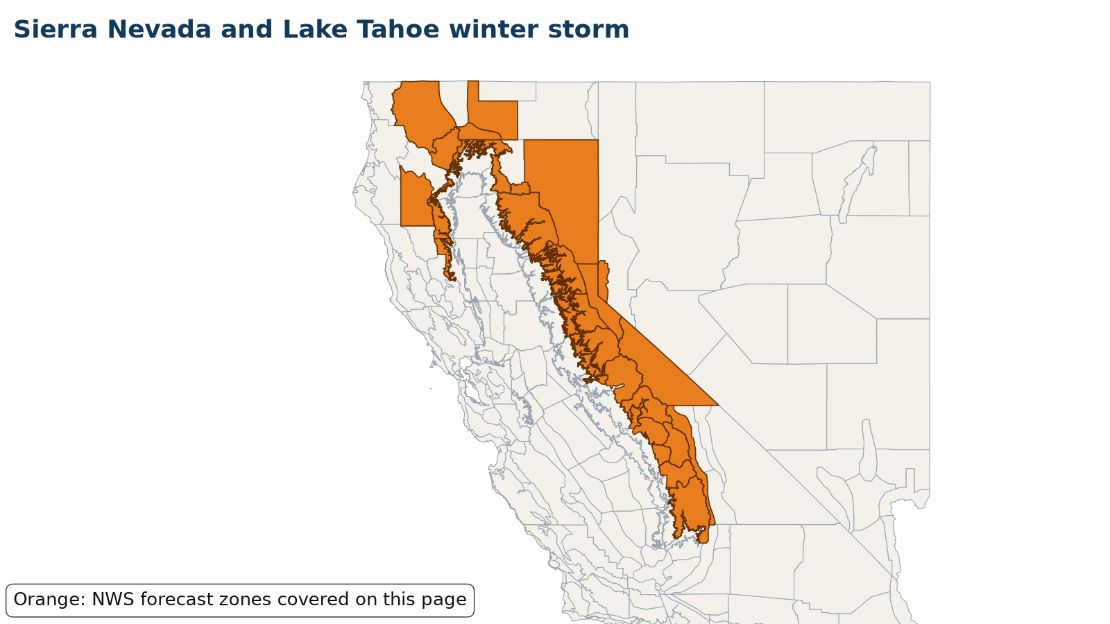
NWS Reno, Sacramento, Hanford, Medford, Eureka and Las Vegas now have Winter Storm Warnings across the Sierra Nevada, Lake Tahoe, Mono County, the southern Cascades, Siskiyou and Shasta county mountains and Trinity County, starting Tuesday evening, Nov. 17, and running as late as 4 a.m. Friday, Nov. 20. NWS Reno forecasts 2 to 4 feet of snow above 7,000 feet and 1 to 2 feet around Lake Tahoe level, 2 to 4 feet in Mono County west of US-395, and ridgetop gusts as high as 100 mph, with 2- to 5-foot waves on Lake Tahoe. NWS Sacramento forecasts 1 to 3 feet above 5,000 feet in the northern Sierra, including Interstate 80, Highway 50 and State Routes 4 and 108, with up to 4 feet on the highest peaks and snowfall rates of 1 to 2 inches an hour Wednesday. NWS Medford forecasts 10 to 18 inches above 4,000 feet in Siskiyou County, with a Winter Weather Advisory for the I-5 corridor between Black Butte Summit and Weed. NWS Hanford's warning covers the southern Sierra above 5,000 feet from 4 a.m. Wednesday to 4 a.m. Friday, with 1 to 2 feet of snow above 5,000 feet, around 4 feet above 8,000 feet, and gusts to 45 mph. NWS Las Vegas upgraded the eastern Sierra slopes of Inyo County to a Winter Storm Warning from 4 a.m. Wednesday to 4 a.m. Friday, with 18 to 36 inches between 8,000 and 9,500 feet and gusts to 55 mph. All offices say travel could be very difficult to impossible, and strong winds could bring down trees and power lines. Check Caltrans QuickMap or NVroads before you travel.
Areas under warnings include the Greater Lake Tahoe area, Mono County, Lassen, eastern Plumas and eastern Sierra counties, the Sierra Nevada along Interstate 80, Highway 50, State Routes 4 and 108, Yosemite, Kings Canyon and Sequoia national parks, the eastern Sierra slopes of Inyo County, Siskiyou County including the I-5 corridor near Mount Shasta, the Shasta County and Coast Range mountains, and Trinity County.
Source: NWS Reno Winter Storm Warnings updated Nov. 17, 2026, 1:44 a.m. PST; NWS Hanford (12:54 a.m.), Las Vegas (Nov. 16, 10:05 p.m.), Sacramento (9:58 p.m.), Medford (10:37 a.m.) and Eureka (11:42 p.m.) Winter Storm Warnings. Warnings change; the live panel below is the current word from NWS.
Let family know you’re OK
Makes a message and picture you can text. Nothing is saved on our servers.
Make a check-in message
Local help near you
Open shelters and FEMA Disaster Recovery Centers in California, Nevada, straight from FEMA.
Loading open shelters…
Follow for storm updates: Facebook (opens in a new tab)X (opens in a new tab)
Live NWS alerts for the affected areas
Loading live data…
FEMA disaster declarations
Loading live data…
Confirmed damage
Only official reports: NWS Local Storm Reports and damage surveys, plus statements from FEMA, USGS and state or county emergency management. No news or social media rumors.
Show storm reports and official statements
Loading NWS storm reports…
Preliminary reports; official totals may change.
Official state and local links
- Caltrans QuickMapCalifornia road conditions and chain controls
- NVroads (Nevada 511)Nevada road conditions
- California Governor's Office of Emergency ServicesState emergency management
- Nevada Division of Emergency ManagementState emergency management
- PG&E outage centerReport and check power outages
- Liberty UtilitiesLake Tahoe-area electric service
- NV Energy outagesReport and check power outages
- NWS RenoForecasts and warnings · NWS
- NWS SacramentoForecasts and warnings · NWS
- NWS HanfordForecasts and warnings · NWS
- NWS MedfordForecasts and warnings · NWS
- NWS EurekaForecasts and warnings · NWS
- NWS Las VegasForecasts and warnings · NWS
During: stay safe
- Stay off roads if at all possible. If you're stranded in your car, stay inside it.
- Never heat your home with a gas stove or oven. Use generators and grills only outdoors, at least 20 feet from windows, doors and attached garages.
- Have working carbon monoxide detectors on every level of your home.
- Limit time outside and dress in layers. Avoid overexertion when shoveling snow.
- Hypothermia (body temperature below 95°F) is an emergency. Warm the center of the body first and call 911.
Source: (Ready.gov: Winter Weather)
After: recover
- Check on older neighbors and anyone without heat or power.
- Report outages to your utility and stay far from downed power lines and tree limbs weighed down by snow.
- Watch for frozen or burst pipes and shut off water at the main if a pipe breaks.
- Photograph roof, tree and water damage before repairs, then contact your insurer.
More official guidance
- NWS winter safetyWarnings, wind chill and travel · NWS
- CDC: Winter weatherBefore, during and after a winter storm · CDC
- Ready.gov: Winter weatherGenerators, frostbite, hypothermia · Ready.gov
- Ready.gov: Power outagesFood, medicine and staying warm · Ready.gov
- Winter outages guideGenerators, CO and frozen pipes
- Home heating safety guideSpace heaters, fireplaces, smoke alarms
- Winter driving guideCar kit, ice and getting stranded
- Extreme cold guideWind chill, frostbite, hypothermia
- Lake effect snow guideSnow bands and snow squalls
- Ice storm guideFreezing rain, black ice and outages
- Frozen pipes guidePrevent, thaw and burst pipes
- Snow on the roof guideSnow load warning signs and safe removal
- Winter storms and ice: full safety guide
Get help
- Power outagesOutage maps and generator safety
- Roads & closures511, road conditions, flooding
- Find shelterOpen shelters and hotel help
- Tarps & roof helpTarps, roof help and volunteer crews
- Mental health & familySomeone to talk to, finding family
- Safety firstGas, power lines, CO, floodwater
- After the storm: housing, mental health, money
- Insurance photo checklist
Common questions
Where can I see current warnings for the sierra nevada and lake tahoe winter storm?
The live panel on this page pulls active alerts straight from the National Weather Service for the affected zones in California, Nevada. You can also check your local NWS office or weather.gov.
Is FEMA assistance available for the sierra nevada and lake tahoe winter storm?
Only if a federal disaster is declared for your county. The FEMA panel on this page shows any declarations as they come in; you can also check DisasterAssistance.gov or call 1-800-621-3362.
What is the difference between a winter storm watch and warning?
Ready.gov says a watch means a blizzard, heavy snow, heavy freezing rain or heavy sleet is possible, usually 12 to 48 hours ahead. A warning means hazardous winter weather is imminent or occurring.
Can I use my oven or gas stove to heat my home?
No. Ready.gov says never heat your home with a gas stovetop or oven, because of carbon monoxide and fire risk.