
Flash flooding in Texas Hill Country and Kingsville area; Oso Creek flood forecast, Nov. 8–11
Do this right now
- Turn around at flooded roads. A foot of moving water can sweep a car away.
- If water is rising around you, move to higher ground now.
- Stay out of floodwater and away from downed power lines.
- Check the live warnings for this area before you travel.
Other active storms: East Central Florida coastal flooding · Southwest flooding: Arizona, Nevada, Utah, N.M., Texas, Colorado · South Florida and Treasure Coast heavy rain flooding
Never walk, swim or drive through floodwater. Ready.gov says just six inches of moving water can knock you down, and one foot of moving water can sweep your vehicle away.
Active. Flood · Texas · Nov. 8, 2026 to Nov. 11, 2026. In danger, call 911.
What is happening
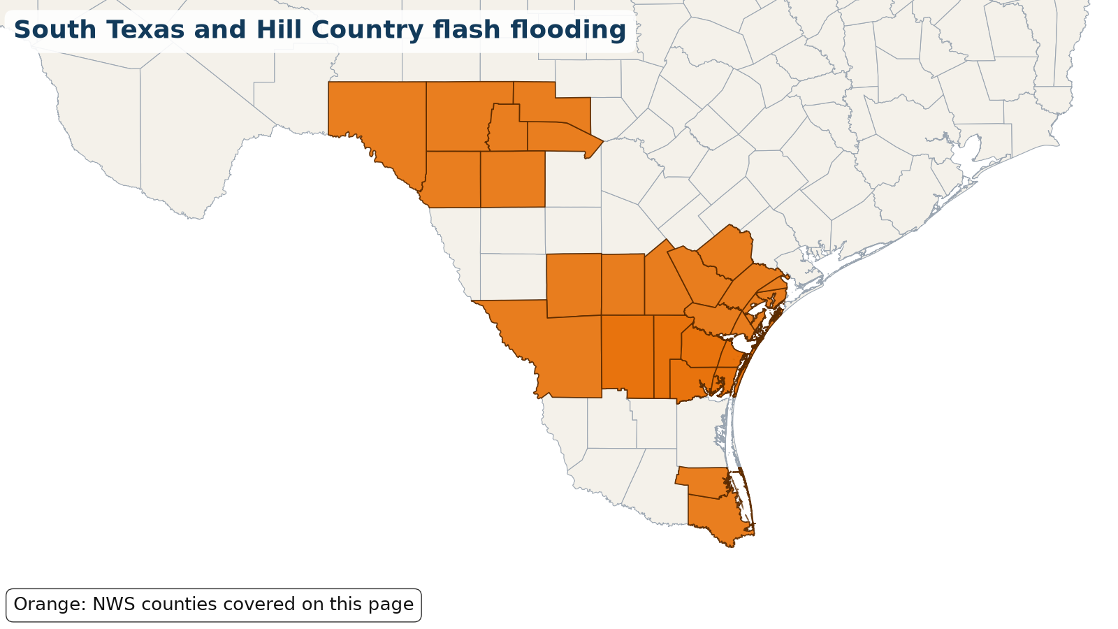
NWS Austin/San Antonio said at 5:13 PM CST Sunday that emergency management reported several flooded roads, including around U.S. 377 from Erwin Draw, and flooding near Kickapoo Cavern State Park and the Devils River area, with a Flash Flood Warning for Edwards, Kinney and Val Verde counties until 8 PM CST after 2 to 5 inches of rain. Earlier Sunday, NWS Corpus Christi said law enforcement reported flash flooding on U.S. 281 and Highway 141 in Kleberg County after 5 to 8 inches of rain, and emergency management reported ongoing minor flooding around Kingsville, Premont and Bishop Sunday evening. A Flood Watch for much of South Texas now runs through noon Monday, with 2 to 4 more inches of rain forecast through Monday evening. Oso Creek near Corpus Christi is forecast to rise above flood stage late Monday morning and crest at 22.3 feet, moderate flooding, late Monday evening before falling below flood stage early Wednesday.
Areas under warnings include Kleberg, Jim Wells and Duval counties including Kingsville and Premont; Nueces County and Corpus Christi (Oso Creek); Cameron and Willacy counties including Brownsville, Harlingen and San Benito; and the Hill Country in Edwards, Real, Bandera, Kerr, Uvalde, Kinney and Val Verde counties including Rocksprings, Leakey, Camp Wood, Barksdale and Concan..
Source: NWS Austin/San Antonio and Corpus Christi active alerts (checked 6:35 PM EST Sunday). Warnings change; the live panel below is the current word from NWS.
Let family know you’re OK
Makes a message and picture you can text. Nothing is saved on our servers.
Make a check-in message
Local help near you
Open shelters and FEMA Disaster Recovery Centers in Texas, straight from FEMA.
Loading open shelters…
Follow for storm updates: Facebook (opens in a new tab)X (opens in a new tab)
Live NWS alerts for the affected areas
Loading live data…
FEMA disaster declarations
Loading live data…
Confirmed damage
Only official reports: NWS Local Storm Reports and damage surveys, plus statements from FEMA, USGS and state or county emergency management. No news or social media rumors.
Show storm reports and official statements
Loading NWS storm reports…
Preliminary reports; official totals may change.
Official state and local links
- Texas Division of Emergency ManagementState emergency management for Texas
- DriveTexasTexas road conditions and closures
- City of Corpus ChristiCity government
- Kleberg CountyCounty government
- Cameron CountyCounty government
- Kerr CountyCounty government
- NWS Corpus ChristiForecasts and warnings · NWS
- NWS Austin/San AntonioForecasts and warnings · NWS
- NWS BrownsvilleForecasts and warnings · NWS
During: stay safe
- Get to safe shelter right away and evacuate if officials tell you to.
- Turn Around, Don't Drown: do not walk, swim or drive through floodwater, and never drive around barricades.
- Stay off bridges over fast-moving water.
- If you're trapped in a building, go to the highest level. Do not climb into a closed attic; only go on the roof if necessary, then signal for help.
- If your car is trapped in rapidly moving water, stay inside. Get on the roof if water rises inside the car.
Source: (Ready.gov: Floods)
After: recover
- Return home only when officials say it's safe.
- Stay out of floodwater: it can be contaminated, hide debris, or be electrically charged by downed lines.
- Don't touch electrical equipment if it's wet or you're standing in water.
- Wear gloves, boots and protective clothing to clean up, and dry your home within 24 to 48 hours to limit mold.
- Homeowners insurance usually doesn't cover flooding; if you have NFIP or private flood insurance, file your claim and photograph everything first.
More official guidance
- NWS flood safetyFlood and flash flood safety · NWS
- National Water Prediction ServiceRiver forecasts and flood levels · NOAA
- Ready.gov: FloodsBefore, during and after · Ready.gov
- Water damage and mold guideDrying out and cleanup
- Flood insurance waiting periodNFIP 30-day wait explained
- Nor'easter and coastal flood guideCoastal flood alerts and what to do
- King tides and sunny-day floodingHigh tide flooding explained
- Flooding: full safety guide
Get help
- Roads & closures511, road conditions, flooding
- Find shelterOpen shelters and hotel help
- Boil-water noticesIs your tap water safe?
- FEMA & money helpAid, loans and free legal help
- Tarps & roof helpTarps, roof help and volunteer crews
- Safety firstGas, power lines, CO, floodwater
- After the storm: housing, mental health, money
- Insurance photo checklist
Common questions
Where can I see current warnings for the south texas and hill country flash flooding?
The live panel on this page pulls active alerts straight from the National Weather Service for the affected zones in Texas. You can also check your local NWS office or weather.gov.
Is FEMA assistance available for the south texas and hill country flash flooding?
Only if a federal disaster is declared for your county. The FEMA panel on this page shows any declarations as they come in; you can also check DisasterAssistance.gov or call 1-800-621-3362.
How much water does it take to sweep away a car?
Ready.gov says one foot of moving water can sweep your vehicle away, and just six inches of moving water can knock you down.
Does homeowners insurance cover flood damage?
Usually not. Ready.gov notes homeowners policies do not cover flooding; flood coverage comes from the National Flood Insurance Program or a private flood policy, which typically takes 30 days to start.